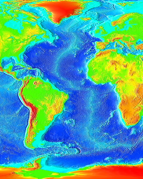
File:Atlantic bathymetry.jpg

Original file (4,000 × 5,000 pixels, file size: 9.12 MB, MIME type: image/jpeg)
Captions
Captions
| DescriptionAtlantic bathymetry.jpg |
English: The Atlantic Ocean. |
| Source | http://www.ngdc.noaa.gov/mgg/image/2minrelief.html |
| Author | NOAA |
| Public domainPublic domainfalsefalse |
This image is in the public domain because it contains materials that originally came from the U.S. National Oceanic and Atmospheric Administration, taken or made as part of an employee's official duties.
العربية ∙ čeština ∙ Deutsch ∙ Zazaki ∙ English ∙ español ∙ eesti ∙ suomi ∙ français ∙ hrvatski ∙ magyar ∙ italiano ∙ 日本語 ∙ 한국어 ∙ македонски ∙ മലയാളം ∙ Plattdüütsch ∙ Nederlands ∙ polski ∙ português ∙ română ∙ русский ∙ sicilianu ∙ slovenščina ∙ Türkçe ∙ Tiếng Việt ∙ 简体中文 ∙ 繁體中文 ∙ +/− |
 |
File history
Click on a date/time to view the file as it appeared at that time.
| Date/Time | Thumbnail | Dimensions | User | Comment | |
|---|---|---|---|---|---|
| current | 19:55, 19 August 2023 |  | 4,000 × 5,000 (9.12 MB) | Kersti Nebelsiek (talk | contribs) | higher resolution |
| 19:20, 27 November 2006 |  | 1,825 × 2,000 (450 KB) | Korrigan (talk | contribs) | Rétablissement de la version précédente | |
| 11:21, 14 November 2006 |  | 547 × 599 (97 KB) | Ludo29 (talk | contribs) | The Atlantic Ocean. Source: http://www.ngdc.noaa.gov/mgg/image/2minrelief.html Récupéré depuis Wikipédia:en avec le même nom | |
| 02:08, 15 March 2006 |  | 1,825 × 2,000 (450 KB) | Interiot~commonswiki (talk | contribs) | change framing | |
| 02:03, 15 March 2006 |  | 1,491 × 2,000 (372 KB) | Interiot~commonswiki (talk | contribs) | == Summary == The Atlantic Ocean. Source: http://www.ngdc.noaa.gov/mgg/image/2minrelief.html == Licensing == {{PD-USGov}} Category:Ocean topography |
You cannot overwrite this file.
File usage on Commons
The following 13 pages use this file:
- Atlantic Ocean
- Atlas of the Oceans
- Earth
- User:Hgrobe/platetectonics
- User:McCormack/gallery
- Commons:Files used on the OpenStreetMap Wiki/2
- File:Cape Verde Rise.jpg
- File:Northeast Atlantic bathymetry.png
- File:Porcupine Bank and Seabight, NE Atlantic.png
- File:Rockall Plateau and Trough, NE Atlantic.png
- Category:Atlantic Ocean
- Category:Geography
- Category:Mid-Atlantic Ridge
File usage on other wikis
The following other wikis use this file:
- Usage on af.wikipedia.org
- Usage on ar.wikipedia.org
- Usage on ast.wikipedia.org
- Usage on az.wikipedia.org
- Usage on az.wiktionary.org
- Usage on bat-smg.wikipedia.org
- Usage on ba.wikipedia.org
- Usage on beta.wikiversity.org
- Usage on be.wikipedia.org
- Usage on bn.wikipedia.org
- Usage on ca.wikipedia.org
- Usage on co.wikipedia.org
- Usage on crh.wikipedia.org
- Usage on cy.wikipedia.org
- Usage on de.wikipedia.org
- Usage on de.wikinews.org
- Usage on de.wiktionary.org
- Usage on diq.wikipedia.org
- Usage on en.wikipedia.org
- Usage on en.wikibooks.org
- Usage on en.wikiversity.org
- Usage on eo.wikipedia.org
- Usage on es.wikipedia.org
- Usage on ext.wikipedia.org
- Usage on fi.wikipedia.org
- Usage on fo.wikipedia.org
- Usage on fr.wikipedia.org
- Usage on fr.wikiversity.org
- Usage on gd.wikipedia.org
- Usage on gl.wikipedia.org
- Usage on he.wikipedia.org
View more global usage of this file.
Metadata
This file contains additional information such as Exif metadata which may have been added by the digital camera, scanner, or software program used to create or digitize it. If the file has been modified from its original state, some details such as the timestamp may not fully reflect those of the original file. The timestamp is only as accurate as the clock in the camera, and it may be completely wrong.
| JPEG file comment | File source: http://commons.wikimedia.org/wiki/File:Atlantic_bathymetry.jpg |
|---|